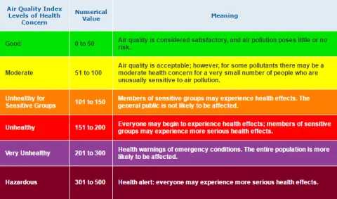
Conditions can change quickly when wildfire smoke fills the air! Bookmark these sites, track air quality, and adjust outdoor activities:
Oregon Smoke Blog: Local, state, tribal and federal organizations coordinate to share information about wildfires and smoke.
EPA Smoke and Fire Map: The Federal Environmental Protection Agency pulls real-time air quality data from state maintained monitors and verified low-cost personal air monitors.
Oregon Air Quality Map: The Department of Environmental Quality updates a map of current air quality (also OregonAir app for your phone).
State of Oregon Fires Map: The Oregon Office of Emergency Management updates a map of active fires, air quality and closures.
For air quality conditions and health guidance on-the-go, download the Smoke Sense App on your phone.
AQI explained video