Updated October 20, 2023
THE 2023 NATURAL HAZARDS MITIGATION PLAN UPDATE WAS ADOPTED BY THE MULTNOMAH COUNTY BOARD OF COMMISSIONERS.
The update to the Multnomah County Multi-Jurisdictional Natural Hazards Mitigation Plan (NHMP) was adopted by resolution of the Multnomah County Board on October 13. The final version of the plan is posted below, and incorporates comment from the Oregon Department of Emergency Management (OEM) and Federal Emergency Management Agency (FEMA). The plan received final federal review approval on August 24, 2023, and may be now be adopted by all of the participating jurisdictions and districts. A list of adoption dates by each multi-jurisdictional partner will be added to this page soon. This plan update was built through stakeholder input, public comment, and the most up-to-date studies and research about natural hazard risk in Multnomah County.
Continuing comments may be submitted through this survey form, with responses to be maintained for future edits or versions of the plan. The plan update and comment form are only available in English. Information about this update and natural hazards in Multnomah County are available in: 中文(Chinese)| Русский (Russian)| Soomaali (Somali)| Español (Spanish)| Tiếng Việt (Vietnamese)
DRAFT PLAN UPDATE CONTENTS
- DocumentNHMP Final Draft - Cover and Table of Contents (763.67 KB)
- DocumentNHMP Final Draft - Chapter 1 - Introduction (602.21 KB)
- Document
- Chapter 3 – Hazard Identification and Risk Assessments
- Document
- DocumentNHMP Final Draft - Section 3.2 - Flood (1.96 MB)
- Document
- DocumentNHMP Final Draft - Section 3.4 - Severe Weather (776.37 KB)
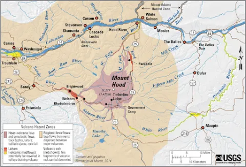
- DocumentNHMP Final Draft - Section 3.5 - Volcano (1.14 MB)
- Document
- Document
- Chapter 5 – Jurisdictional/District Sections
- Document
- Document
- Document
- Document
- Document
- Document
- Document
- Document
- Document
- Document
What is the Natural Hazards Mitigation Plan and why is it being updated?
Every five years, Multnomah County is required by the Federal Emergency Management Agency (FEMA) to update its Natural Hazards Mitigation Plan (NHMP). This plan uses the best available information about natural hazards to come up with actions to protect life, property and the environment in future natural disasters. The current plan was completed in 2017, and will be updated in 2023 by local adoption, after approval from FEMA and the Oregon Department of Emergency Management (OEM).
What is Hazard Mitigation?
Hazard mitigation is the work that is done before a disaster occurs, to lessen the severity of future natural disasters and make the community more resilient.
Successful hazard mitigation projects protect lives and property and also save the community money in the long run. It is estimated by FEMA that for every dollar spent on hazard mitigation, up to six dollars are saved when disasters strike.
What Hazards Are Covered in This Plan?
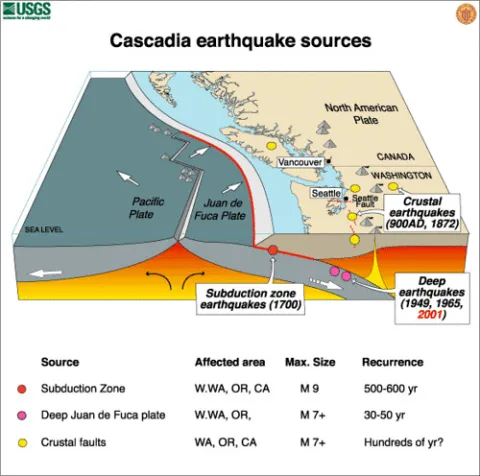
This plan only covers natural hazards; human-caused disasters such as terrorism and hazardous materials are covered in other plans. The State of Oregon lists natural hazards that have impacts across Oregon. Multnomah County communities plan for all of those except for coastal erosion and tsunami, which generally only damage coastal communities.
Multnomah County's hazard mitigation plan addresses the hazards listed below. The majority of these hazards are being impacted by climate change, and so it is more important than ever to prepare, because current information may underestimate the amount of risk we face.
- Increasing public awareness of risk and how to respond in an earthquake.
- Assisting residents gathering supplies in their homes to use after a severe earthquake.
- Supporting strengthening of bridges, levees, stone buildings, and other structures.
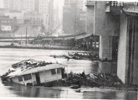
- Strengthening levees, dams, and floodwalls.
- Preserving floodplains as open space.
- Encouraging flood insurance to increase resilience of homes and businesses.
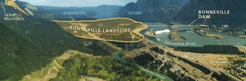
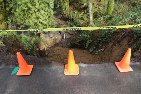
- Stabilizing slopes with trees and other vegetation.
- Limiting new construction in the highest hazard areas.
SEVERE WEATHER includes extreme heat, winter storms, wind storms, and drought. Unfortunately, all of these hazards are becoming more extreme and unpredictable due to climate change.

- Reducing urban heat effects by planting more trees.
- Advertising summer and winter shelter planning for those without climate-controlled living spaces.
- Promoting the use of anchors and tie-downs to protect manufactured homes in high winds.
- Publicizing community evacuation routes.
- Developing improved early warning systems.
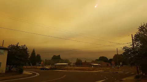
- Assisting homeowners to create defensible space around homes and other structures.
- Removing invasive species to make forests more fire resistant.
- Upgrading air filtration in spaces that can be used as clean-air shelters.
To learn more about these hazards, go to Community Resources for Hazard Mitigation (English only). You can see maps of hazards at the following websites:
- HazVu - Oregon Department of Geology and Mineral Industries (DOGAMI) site shows earthquake, landslide, and volcano risk by address throughout Oregon. (In English)
- Oregon Wildfire Explorer - Oregon Department of Forestry (ODF) site shows wildfire risk by address throughout Oregon. (In English)
- National Flood Hazard Layer (NFHL) - Federal Emergency Management Agency (FEMA) website shows mapped flood risk by address across the United States. (In English)
- Metro Regional Barometer - Climate and Environment - Series of Metro Regional Government maps including Urban Heat Islands - locations where heat risk is the most severe. (In English)
Questions?
Contact David Lentzner, Planning Division - david.lentzner@multco.us or by phone at 503.679.3275.